

/ Customised table query and maps viewer


The data offered in this system have been compiled out of the sample information provided by more than 2.3 million householdsthat took part in the operation of the Population and Housing censuses 2011. The data is presented rounded in order to preserve the Statistical Secrecy/confidenciality; consequently, the results for some characteristics are different from those provided in the pre-defined tables.
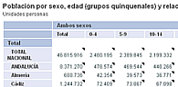
This way of access allows the creation of tables selecting the variables desired and, once the table is created, this will facilitate navigating through the information in order to get into deep details, change the source territory, establish filters or restrictions, etc. Moreover, we provide tools in order to carry out the graphs and thematic maps from the information consulted.
An accessible version is also available, according to regulation UNE 139803:2012
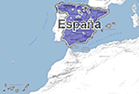
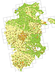
Maps viewer
With this option there are different types of queries available:
- Define a geographical area and check the pre-definite indicators for this area.
- Define a geographical area and transfer the selection to the Customised table query system.
- Show thematic pre-defined maps,...
According to the approach degree or zoom of the map, we can establish a selection by Autonomous Community, Province, Municipality, District or Census section Queries can also be defined outside the administrative borders using a statistical information grid.
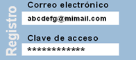
No previous registry is needed in order to access the query tables and the map viewer. Only registered users can storage table queries, filters, breakdowns and geographical areas previously defined in order to use them in later sessions.